Milestone for an icon
 |
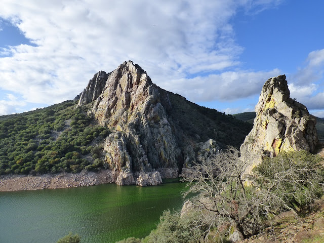
| Peña Falcón in Monfragüe National Park (Martin Kelsey) |
Erupting as a ribbon of parallel ridges across an ocean of dehesa, the hard quartzite strata stand as proud relics to the turbulance of the Variscan orogeny, the tectonic movements that formed the supercontinent Pangea. The results of this collision between the ancient masses of Euramerica and Gondwana can be found in the form of the Pyrenees, some of the Alps (including Mont Blanc) and here in Extremadura, the syncline that shapes the Monfragüe National Park. Standing amongst the visitors at the viewpoint in the southern entrance to the park, I look across onto the the massive Peña Falcón (the Falcon's Rock: which indeed does host a pair of Peregrines). The rock strata laid horizontally as sand on beaches and under the sea about 500 million years ago were metamorphosed into quartzites and slates, violently folded 200 millions years later and pushed vertically as waves across the Earth's crust.
"Think about geology to understand landscape" a geologist once told me. Below me the Tagus (Tajo) River flows from the right. There it had sought the route of least resistance, smoothing a valley through the softer and friable layers of slate until she hit the wall of quartzite. Gravity drew her direction of travel southward and it was at this point where through a long-gone fault or weakness in the rock, the water pushed through. Over millions of years of erosion, the gateway or Portilla, was formed, creating this iconic gorge.
 |
| Prehistoric rock art in Monfragüe (Martin Kelsey) |
The overhangs and crevices in the quartzite offered refuges for the first human visitors to Monfragüe and thus started the agency of the human hand and mind in shaping this landscape. The rock paintings just below the castle in Monfragüe date back 11,000 years. The name Monfragüe itself is derived from the Roman "Monsfragorum" which means a rocky zone with abrupt relief, but also lush: describing perfectly the vast Mediterranean mixed forest which still covers the north-facing slope of the castle ridge. In medieval times a bridge was built crossing the Tagus, visible to this day when the water level is low enough, but travellers were at risk from attack by bandits hiding in the steep, wooded terrain. The rocky hillsides and impenetrable vegetation also provided cover for groups of maquis, guerrilla fighters who maintained resistence against the Franco regime for several years after the Civil War.
 |
| The Cardinal's Bridge, built in 1450 and today only visible when the water level is low enough (Martin Kelsey) |
The dehesa wood pasture was developed across the vast latifundias, the estates bestowed by the monarchs after the Reconquest, and which still define much of the land tenure around Monfragüe. For centuries the landscape would have changed little. This was until the 1960s when a dramatic new chapter in Monfragüe's history opened. Dams were built across the great Tagus (one inside what is now the park) and another downstream at Alcántara. The result was to change forever the way in which the river passed through the gorge, replacing waterfalls and rocky torrents with the sluggish feel of a backwater. And then, at the end of the decade, work started to convert the hillsides of native Mediterranean woodland into vast and sterile eucalyptus and pine plantations for pulp and paper production.
It was at that time when perhaps Monfragüe's most significant visitor first set foot in the area. Jesús Garzón was studying Spanish Imperial Eagles and was staggered to experience a place where it was possible without leaving the road to obtain unequalled views of timid species like Black Storks, five species of eagle and nesting vultures. These deep impressions are shared even today by the numerous visitors that gather at the viewpoints in the park. But he saw too how this extraordinary place was being ripped apart by the conversion of land underway, and with much more under threat. He spearheaded a campaign in the early 1970s, involving conservationists, activists and, significantly, local schools to oppose the spread of eucalyptus. These were times of great change in Spain with the death of Franco and the transition to democracy. The campaign struggled against what was then government policy and the interests of big business. But the public voice triumphed - indeed Garzón says that "Monfragüe was saved by the local children".
 |
| Campaign material from 1973 to mobilise people to save Monfragüe (from the historic archives of Monfragüe National Park) |
Exactly 40 years ago the objectives of the campaign were realized with the declaration of Monfragüe as a Natural Park and a change in government policy to prohibit the planting of eucalyptus in the Mediterranean region of the country. Over a decade ago, Monfragüe was further upgraded to a National Park, covering over 18,000 hectares, sitting in the middle of a Biosphere Reserve of over 110,000 hectares. This vast buffer zone is crucial for the integrity of the park, offering foraging ranges over dehesa farmland for the breeding birds of prey, most notably the world's highest density of Black Vultures, a species that has increased tenfold in Extremadura since Jesús Garzón's first fell in love with Monfragüe.


Comments